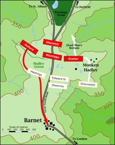
 Perhaps the only historic battle site in Greater London, the Battle of Barnet was a decisive battle in the War of the Roses. It was decisive, because Edward’s victory led to 14 years of Yorkist rule in England. English Heritage, a government body in charge of conservation of historic sites, demarcates the battlefield as lying 800 to 1600 metres (0.5 to 1.0 mile) north of the town of Barnet. English Heritage suggests that a 15th-century letter from a Hanseatic merchant, Gerhard von Wessel, helps to identify the battlefield via geological features. It mentions a “broad green” which corresponds to Hadley Green, and the marsh on the right flank of the Yorkist line is likely to be in the valley of the Monken Mead brook. The letter also mentions St Albans road, which has remained largely the same, winding through the fields. Urbanisation over the 18th and 19th centuries, however, has populated much of the area with buildings. By the 20th century, the Monken Hadley suburb covered part of the fields where the Battle of Barnet was fought. A hedge in the local golf course, as suggested by Lieutenant-Colonel Alfred H. Burne, is likely the row of shrubs behind which Oxford’s men lined up and took cover.
In 1740, Sir Jeremy Sambroke erected an obelisk to commemorate the battle about 200 metres (660 ft) south of the junction between the Great North Road and Kitts End Road. It was later moved just north of the junction on the grass between the two roads. Known as Hadley Highstone, it stands 5.5 metres (18 ft) tall and marks its location with the inscription: “Here was fought the Famous Battle Between Edward the 4th and the Earl of Warwick April the 14th ANNO 1471 in which the Earl was Defeated And Slain.”
If visiting this area, Monken Hadley Common (or Hadley Woods) is the only remaining part of Enfield Chase - and a haven for wildlife, walking and nature. Learn more at http://www.monkenhadleycommon.net/
Closest tube: High Barnet
